


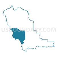
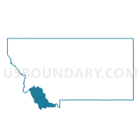
Precinct 8, Beaverhead County, Montana
About
Outline

Summary
| Unique Area Identifier | 611824 |
| Name | Precinct 8 |
| County | Beaverhead County |
| State | Montana |
| Area (square miles) | 737.94 |
| Land Area (square miles) | 736.09 |
| Water Area (square miles) | 1.85 |
| % of Land Area | 99.75 |
| % of Water Area | 0.25 |
| Latitude of the Internal Point | 44.90715060 |
| Longtitude of the Internal Point | -113.12998850 |
Maps

Graphs
Select a template below for downloading or customizing gragh for Precinct 8, Beaverhead County, Montana


Neighbors
Neighoring Voting District (by Name) Neighboring Voting District on the Map
- Junction Voting District, Lemhi County, ID
- Lemhi Voting District, Lemhi County, ID
- Precinct 19, Beaverhead County, MT
- Precinct 2, Beaverhead County, MT
- Precinct 20, Beaverhead County, MT
- Precinct 5, Beaverhead County, MT
Top 10 Neighboring County Subdivision (by Population) Neighboring County Subdivision on the Map
- Salmon CCD, Lemhi County, ID (6,739)
- Leadore CCD, Lemhi County, ID (619)
- Big Hole Basin CCD, Beaverhead County, MT (615)
- Clark Canyon-Horse Prairie CCD, Beaverhead County, MT (376)
- Lima-Centennial Valley CCD, Beaverhead County, MT (375)
Top 10 Neighboring Elementary School District (by Population) Neighboring Elementary School District on the Map
- Dillon Elementary School District, MT (7,757)
- Jackson Elementary School District, MT (152)
- Grant Elementary School District, MT (142)
Top 10 Neighboring Secondary School District (by Population) Neighboring Secondary School District on the Map
Top 10 Neighboring Unified School District (by Population) Neighboring Unified School District on the Map
- Salmon School District 291, ID (7,154)
- South Lemhi School District 292, ID (625)
- Lima K-12 Schools, MT (508)
Top 10 Neighboring State Legislative District Lower Chamber (by Population) Neighboring State Legislative District Lower Chamber on the Map
Top 10 Neighboring State Legislative District Upper Chamber (by Population) Neighboring State Legislative District Upper Chamber on the Map
Top 10 Neighboring 111th Congressional District (by Population) Neighboring 111th Congressional District on the Map
Top 10 Neighboring Census Tract (by Population) Neighboring Census Tract on the Map
- Census Tract 9702, Lemhi County, ID (2,984)
- Census Tract 9703, Lemhi County, ID (2,465)
- Census Tract 1, Beaverhead County, MT (1,366)
Top 10 Neighboring 5-Digit ZIP Code Tabulation Area (by Population) Neighboring 5-Digit ZIP Code Tabulation Area on the Map
- 59725, MT (7,963)
- 83467, ID (6,270)
- 83464, ID (345)
- 83468, ID (170)
- 59724, MT (128)
- 59736, MT (127)
- 83465, ID (109)